Commissioners celebrate funding for trails

Chester County Commissioners Josh Maxwell, Marian Moskowitz and Eric Roe were on hand recently to celebrate new funding for trails in Chester County.
Greater Philadelphia is now leading the nation in utilizing federal Carbon Reduction Program funds for active transportation, and Chester County is celebrating this major moment for the region.
In late July, the Delaware Valley Regional Planning Commissioner...
Chesco Planning completes trail study, calls for new projects

The Chester County Planning Commission recently wrapped up an 18-month study to determine the feasibility of developing a multi-use trail connecting Chester County’s southern communities to the Circuit – Greater Philadelphia’s existing multi-use trail network.
Major project recommendations included 20 miles of bicycle and pedestrian improvements along Baltimore Pike to create a unified “Baltimore...
County to enforce speed limits on trails
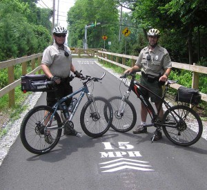
Regional Rangers Mike Trzaska (left) and Jay Erb (right) are two of eleven rangers that regualarly patrol the length of the Chester Valley Trail. They cooperate with local police to keep the trail safe and to educate trail users on sharing space on the trail.
WEST CHESTER — Chester County is placing 15 mph speed limit markers on Chester Valley and Struble trails to improve safety for the tens of...
New Pocopson trail completed
Barnard House update, deer management committee ready for fall
By Kelli Siehl, Staff Writer, The Times
The Brandyridge Trail near West Creek Road in Pocopson is the newest trail completed by the township’s Public Works Department.
POCOPSON — Township officials made quick work of agenda items during Monday’s Township Board of Supervisors’ Meeting.
Mark Knightly, Township Director of Public...
On The Trail: Valley Garden Park

Where: Campbell Road, just off Route 52, Wilmington, Delaware 19807
Map: http://goo.gl/maps/1xbbe
The name Valley Garden Park perfectly captures the setting of this small park, beautifully landscaped and well maintained. According to a plaque in the park, it was donated to the City of Wilmington by DuPont Wheelwright in memory of her mother, Mrs. T. Coleman DuPont, whose brainchild it was.
To get to...
On The Trail: Goose Creek Park

Round trip distance: ~0.5mile (can be extended to about 0.7mile by taking unpaved side trails)
Difficulty: Easy
Information: http://www.thornburytwp.com/PDF/Park%20Facilities.pdf
Trail map: https://maps.google.com/maps?hl=en&tab=ml
This is a tiny park, at a total of about 12 acres, but what it lacks in size it makes up for in character. Views and serenity are abundant, as are park benches from...
On The Trail: Goddard Park; West Grove Township

Round trip distance: About 2 miles
Difficulty: Easy
Website: http://www.london-grove.pa.us/index.asp?Type=B_BASIC&SEC=%7B8E08CC3F-1E43-412F-836C-223E1F993BD9%7D
Trail Map: https://maps.google.com/maps?hl=en&tab=ml
Trail Photos: https://picasaweb.google.com/111242976600600025974/GoddardPark
Goddard Park came into being earlier this year. I have been walking in this area regularly for a couple...
On The Trail: The Laurels

The Laurels – Shady Loop Trail
Round trip distance: 4 miles round trip in the shade; additional 2 miles with the out-and-back side trails
Difficulty: Easy to moderate
Caution: Closed for hunting on occasion during deer season. Heed posted signs.
Website: http://www.brandywineconservancy.org/laurelsPreserve.html
Trail Map: http://goo.gl/maps/L9DpS (trail map is approximate)
Membership Information:...
On the Trail: Myrick Conservation Center

By Vidja Rajan, Columnist, The Times
The H. E. Myrick Conservation Center, Pocopson Township
Round trip distance: 3 miles (can be extended to about 5 miles)
Difficulty: Moderate – occasional steep slopes
Caution: Hunting during the winter deer season. Times are posted. Wear blaze orange and keep dogs on leash.
Website: http://www.brandywinewatershed.org/2008/about/myrick.asp
Directions: http://goo.gl/maps/67Dh
Trail...


Op/Ed: Trails are no longer a luxury, but a must-have in many communities