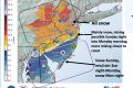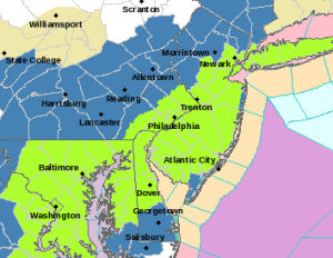
Although computer modeling shows a wide variation of possibilities, the National Weather Service now sees the area in light green as the most likely storm track and has issue a Blizzard Watch — a combination of heavy snow and high winds is possible — from Friday night through Sunday for southeastern Chester County, with snow totals in the 12 to 18 inch range.
Although there were still some variations in the computer modeling — which still offered a maddening forecast range locally of between two and 25 inches of snow this weekend — the National Weather Service issued a Blizzard Watch Thursday morning for the southeastern portions Chester County area from Friday evening through Sunday. The rest of the county remains on a Winter Storm Watch.
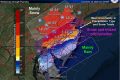
The odds of a major snow event this weekend appear to be much stronger now — and the nature of the likely storm, with possible heavy snow, high winds (gusts up to 39 MPH) and coastal flooding make it appear to be among the more serious storms to hit the area in the last decade. The NWS forecast calls for 12 to 18 inches of snow, with Chester County appearing to be the dead center of the most likely storm track, which appears to run from Washington, DC through Philadelphia to New York City.
Because temperatures are expected to be near the freezing mark, the potential for wet, heavy snow combined with high winds could lead to power outages, caused by downed tree limbs and power lines. PECO is moving in additional personnel from its Com Edison division in Chicago to assist with restorations.
Meanwhile local officials are suggesting that residents take common sense precautions for the storm and a possible power outage. If there are heavy snows and high winds, local officials caution that travel should be restricted to emergencies — keeping off the roadways during the peak of the storm is best way to allow municipal and state workers to keep roads passable for emergency vehicles and to allow PECO to get to repair sites. Also, with the heavy snow and winds, tree branches could become dangerous projectiles — a hazard to motorists.
A few preparations will make the storm less of a hazard, officials say.
The Chester County Department of Emergency Services offers these tips from ready.gov:
• Before winter approaches, add the following supplies to your emergency kit:
◦ Rock salt or more environmentally safe products to melt ice on walkways. Visit the Environmental Protection Agency for a complete list of recommended products.
◦ Sand to improve traction.
◦ Snow shovels and other snow removal equipment.
◦ Sufficient heating fuel. You may become isolated in your home and regular fuel sources may be cut off. Store a good supply of dry, seasoned wood for your fireplace or wood-burning stove.
◦ Adequate clothing and blankets to keep you warm.
• Make a Family Communications Plan. Your family may not be together when disaster strikes, so it is important to know how you will contact one another, how you will get back together and what you will do in case of an emergency.
• A NOAA Weather Radio broadcasts alerts and warnings directly from the NWS for all hazards. You may also sign up in advance to receive notifications from your local emergency services.
• Download FEMA’s Be Smart. Know Your Alerts and Warnings for a summary of notifications at: www.ready.gov/prepare. Free smart phone apps, such as those available from FEMA and the American Red Cross, provide information about finding shelters, providing first aid, and seeking assistance for recovery.
• Minimize travel. If travel is necessary, keep a disaster supplies kit in your vehicle.
• Bring pets/companion animals inside during winter weather. Move other animals or livestock to sheltered areas with non-frozen drinking water.